
City of Rivers
Since the beginning, the topography and development of Sheffield has been defined by its waterways. They’ve been the heartbeat of the city, the reason people originally settled in this spot, first feeding industry and later sparking joy and tranquillity. The relationship Sheffielders have with the rivers has changed over the centuries, from a working relationship to a more recreational one, but they have always been a defining feature of the city.
Sheffield has 5 main rivers - The Don, The Porter Brook, The Loxley River, The Rivelin River and The Sheaf. The Sheaf is in fact where Sheffield derives its name from.

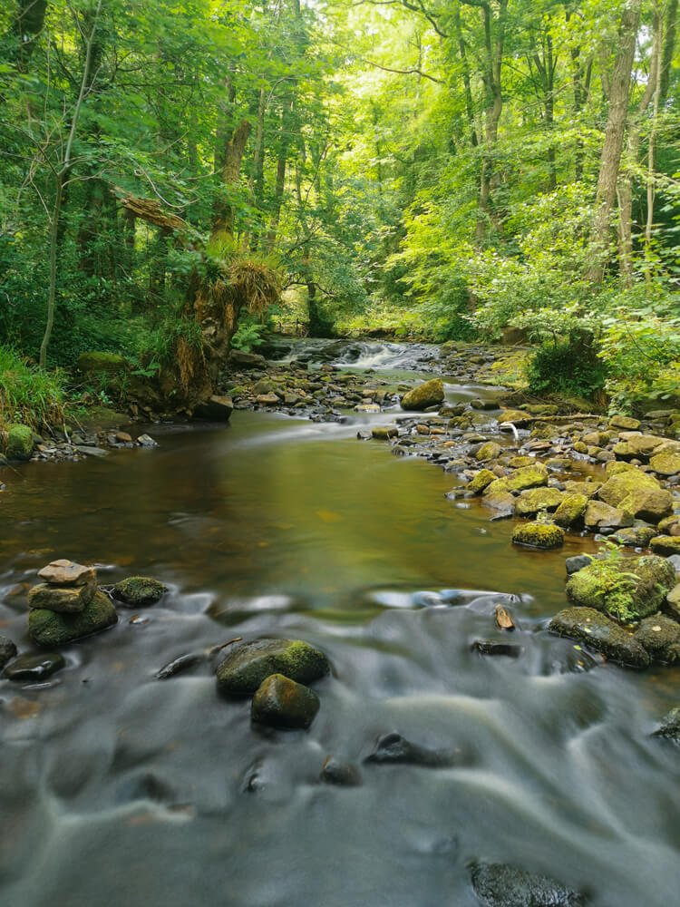
Most of the rivers on the west side of the city (the Porter, Rivelin, Loxley & Sheaf) all rise from springs high up on the moors on the edge of the Peak District (Burbage, Hallam, Bradfield and Totley Moors respectively), the water flowing steeply down towards the town making the perfectly fast-flowing to be used for powering mills. By 1740, 90 mills had been built, making Sheffielf the greatest user of water-power in Britain, maybe even in Europe! In Rivelin Valley alone, you could find 21 artificially created ponds, powering 20 mills which were mainly used for grinding knives and other steel blades that made Sheffield famous. ‘Nether Cut’ was the last mill to work in the valley, still producing grinding scythes until 1939.
As industry declined, the corn, paper and grinding mills were slowly demolished. This allowed the health of the rivers to gradually improve - The Don, once an open sewer and allegedly so full of chemical waste it was toxic enough to set on fire - little by little grew cleaner, until fish returned to its waters from the 1980s. A fun fact, this river at one time flowed so hot (rising above 20 degrees) because of the heat from the foundries nearby that fig trees germinated on its banks (unheard of in UK in the mid 20th century, but thanks to global warming today, it’s not such an oddity). Now that the water temperature has reduced, most of these trees are over 50 years old, with no evidence of new ones having grown since.
Now, the river valleys form green corridors which break up the urban sprawl, they’re magical places which bring the countryside into the city. On the west side of Sheffield, these lush, watery passageways link the city to the Peak District, allowing people to travel by foot or bike between the urban and rural landscapes with absolute ease. Sheffield prides itself of being ‘the outdoor city’, and this is thanks hugely to its network of brooks and rivers.
Below are some of my favourite shots from along Rivelin Valley, including a few of Wyming Brook (a tributary of the Rivelin, flowing between Redmires and Rivelin Reservoirs).


However, on entering the city centre, one by one the rivers seem to disappear, until you’re left with just the Don, winding its way around Kelham Island. All the Don’s tributaries were culverted - re-directed underground into a series of tunnels, some of which are famously enormous, like the huge Victorian brick-arched ‘Megatron’. This work was done back when the rivers were filthy, life-less environments, so putting them underground was seen as beneficial and also made building housing and infrastructure much easier. Now though, some sections are being de-culverted in a scheme called ‘daylighting’. You can now see stretches of Sheffield’s ‘hidden rivers’ and their layers of history at Pocket Park on Matilda Street and on the banks of the Don at Nursery Street.
Weston Park Museum’s latest exhibition ‘City of Rivers’ aims to bring the city’s waterways into focus. Now Then magazine have written a brilliant piece on what to expect of the exhibition, which you can read here. I was horoured to be asked to create map of the region for the showcase, and Now Then wrote about it so eloquently, I have copied that section for you to read below -
“The centrepiece will be a topographical metal map of Sheffield, including engraved rivers and silver reservoirs, commissioned from Holly Clifford of Contour Map Collection specially for the show. “It was a very special map to make, because the topography and history of Sheffield is defined by its rivers,” Clifford told Now Then.
‘They’re the city’s watery main arteries, initially a source for huge industry, but which now are magical and lush green corridors linking the city to the Peak District. I believe that maps are great holders of our memories, the landscape intertwined with events and emotions that occurred there. I hope that when people look at this map it conjures joy of places and experiences, just like it does for me.’
The map has been created from one single sheet of blackened brass. Using elevation data, Clifford then cut the contour lines of the landscape into the sheet using a laser, with each one representing a 25-metre change in the landscape.
‘All the rivers were then hand engraved into the metal and meticulously filled with silver leaf, the reservoirs studded along them cut by hand from sheet silver and riveted in place,” she said. “A true labour of love!’ “
City of Rivers opens on the 24th November 2023, and runs until 3rd November 2024.


